

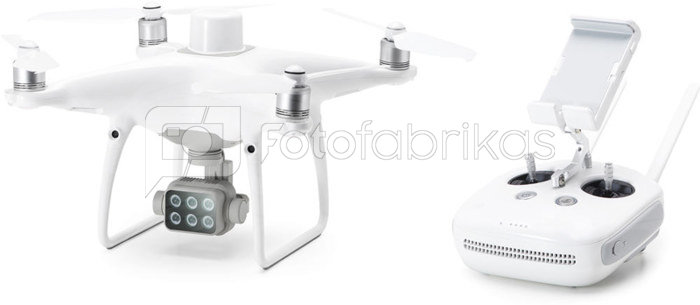
DJI specializuotas dronas Phantom 4 Multispectral, ypač tinkantis panaudoti agro kultūroje įsivertinant augalų augimo vegetacijos procesą bei galimybė sukurti jo 3d žemėlapį, kad geriau paskirstyti trašas bei purškimą. Dėl naujos kartos sistemų matavimo duomenys realiu laiku gaunami centimetrų tikslumu. Užtikrintas skrydžio signalas ir stabilumas net ir tose vietovėse, kuriuose daug signalo trukdžių. Valdymo pultas su pritvirtintu ryškiu ekranu.
Takeoff Weight
1487 g
Diagonal Distance (Propellers Excluded)
350 mm
Max Service Ceiling Above Sea Level
19685 ft (6000 m)
Max Ascent Speed
6 m/s (automatic flight); 5 m/s (manual control)
Max Descent Speed
3 m/s
Max Speed
31 mph (50 kph) (P-mode); 36 mph (58 kph) (A-mode)
Max Flight Time
Approx. 27 minutes
Operating Temperature
0° to 40° C (32° to 104° F)
Operating Frequency
2.4000 GHz to 2.4835 GHz (Europe, Japan, Korea)
5.725 GHz to 5.850 GHz (Other countries/regions)[1]
Transmission Power (EIRP)
2.4 GHz: < 20 dBm (CE / MIC / KCC)
5.8 GHz: < 26 dBm (FCC / SRRC / NCC)
Hover Accuracy Range
RTK enabled and functioning properly:
Vertical: ± 0.1 m; Horizontal: ± 0.1 m
RTK disabled:
Vertical: ± 0.1 m (with vision positioning); ± 0.5 m (with GNSS positioning)
Horizontal: ± 0.3 m (with vision positioning); ± 1.5 m (with GNSS positioning)
Image Position Compensation
The relative positions of the centers of the six cameras’ CMOS and the phase center of the onboard D-RTK antenna have been calibrated and are recorded in the EXIF data of each image.
Ground Sample Distance (GSD)
(H/18.9) cm/pixel, H indicates the aircraft altitude relative to the area mapped (unit: m)
Rate of Data Collection
Max operating area of approx. 0.63 km2 for a single flight at an altitude of 180 m, i.e., GSD is approx. 9.52 cm/pixel, with a forward overlap rate of 80% and a side overlap ratio of 60%, during a flight that drains the battery from 100% to 30%.
Single-Frequency High-Sensitivity GNSS
GPS + BeiDou + Galileo[2] (Asia); GPS + GLONASS + Galileo[2] (other regions)
Multi-Frequency Multi-System High-Precision RTK GNSS
Frequency Used
GPS: L1/L2; GLONASS: L1/L2; BeiDou: B1/B2; Galileo[2]: E1/E5
First-Fixed Time: < 50 s
Positioning Accuracy: Vertical 1.5 cm + 1 ppm (RMS); Horizontal 1 cm + 1 ppm (RMS).
1 ppm indicates error with a 1 mm increase over 1 km of movement.
Velocity Accuracy: 0.03 m/s
Controllable Range
Tilt: -90° to +30°
Velocity Range
≤ 31 mph (50 kph) at 6.6 ft (2 m) above ground with adequate lighting
Altitude Range
0 - 33 ft (0 - 10 m)
Operating Range
0 - 33 ft (0 - 10 m)
Obstacle Sensory Range
2 - 98 ft (0.7 - 30 m)
Operating Environment
Surfaces with clear patterns and adequate lighting (> 15 lux)
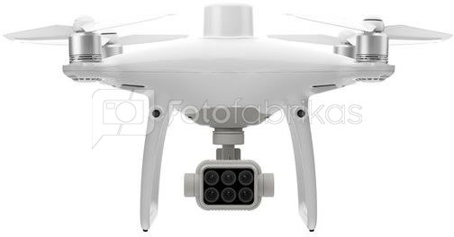
Sensors
Six 1/2.9” CMOS, including one RGB sensor for visible light imaging and five monochrome sensors for multispectral imaging.
Each Sensor: Effective pixels 2.08 MP (2.12 MP in total)
Filters
Blue (B): 450 nm ± 16 nm; Green (G): 560 nm ± 16 nm; Red (R): 650 nm ± 16 nm; Red edge (RE): 730 nm ± 16 nm; Near-infrared (NIR): 840 nm ± 26 nm
Lenses
FOV (Field of View): 62.7°
Focal Length: 5.74 mm (35 mm format equivalent: 40 mm), autofocus set at ∞
Aperture: f/2.2
RGB Sensor ISO Range
200 - 800
Monochrome Sensor Gain
1 - 8x
Electronic Global Shutter
1/100 - 1/20000 s (visible light imaging); 1/100 - 1/10000 s (multispectral imaging)
Max Image Size
1600×1300 (4:3.25)
Photo Format
JPEG (visible light imaging) + TIFF (multispectral imaging)
Supported File Systems
FAT32 (£ 32 GB); exFAT (> 32 GB)
Supported SD Cards
microSD with a minimum write speed of 15 MB/s. Max Capacity: 128 GB. Class 10 or UHS-1 rating required
Operating Temperature
0° to 40° C (32° to 104° F)
Operating Frequency
2.4000 GHz to 2.4835 GHz (Europe, Japan, Korea)
5.725 GHz to 5.850 GHz (Other countries/regions)[1]
Transmission Power (EIRP)
2.4 GHz: < 20 dBm (CE / MIC / KCC)
5.8 GHz: < 26 dBm (FCC / SRRC / NCC)
Max Transmission Distance
FCC / NCC: 4.3 mi (7 km)
CE / MIC / KCC / SRRC: 3.1 mi (5 km)(Unobstructed, free of interference)
Built-in Battery
6000 mAh LiPo 2S
Operating Current / Voltage
1.2 A @ 7.4 V
Mobile Device Holder
Tablets and smartphones
Operating Temperature
0° to 40° C (32° to 104° F)
Capacity
5870 mAh
Voltage
15.2 V
Battery Type
LiPo 4S
Energy
89.2 Wh
Net Weight
468 g
Operating Temperature
-10° to 40° C (14° to 104° F)
Charging Temperature
5° to 40° C (41° to 104° F)
Max Charging Power
160 W
Voltage
17.5 V
Operating Temperature
5° to 40° C (41° to 104° F)
Voltage
17.4 V
Rated Power
160 W
Pristatymo laikas 5-19 d.d.
| Gamintojas(?) | DJI |
|---|---|
| Pristatymo laikas | 5-19 d.d. |
| Prekės kodai |
09435KVG CP.AG.00000207.01 6958265197963 |


Atsiliepimai
0 vidutinis įvertinimas (0 įvertinimų)