
Email: [email protected]


The DJI Zenmuse L2 is an integrated geospatial data acquisition system. DJI Zenmuse L2 integrates frame LiDAR, a high-accuracy IMU system, and a 4/3 CMOS RGB mapping camera, providing DJI flight platforms with more precise, efficient, and reliable geospatial data acquisition. When used with DJI Terra, it delivers a turnkey solution for 3D data collection and high-accuracy post-processing. Supported by its powerful hardware, DJI Zenmuse L2 can allow for a precise scan of complex subjects within an extended range and faster point cloud acquisition. During operations, users can preview, playback, and process point cloud models on-site, with Task Quality Reports generated by DJI Terra, offering a simple, one-stop solution to improve overall efficiency. This enables users to achieve high-precision point cloud results with one-stop post-processing.
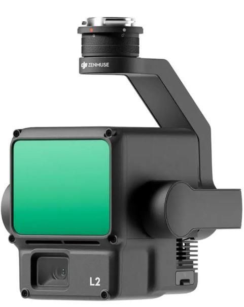
By combining GNSS and a high-accuracy self-developed IMU, this solution achieves 4 cm vertical accuracy and 5cm horizontal accuracy.
It’s ready for work as soon as it’s powered on and can collect both geospatial and RGB data from a 2.5 km2 area in a single flight.
In conjunction with Matrice 350 RTK and DJI Terra, DJI Zenmuse L2 offers a turnkey solution that is simple to use, lowering the operational threshold.
L2 can detect from 250 meters at 10% reflectivity and 100 klx, and up to 450 meters at 50% reflectivity and 0 klx. The typical operational altitude now extends up to 120 meters, notably enhancing operational safety and efficiency.

With a reduced spot size of 4×12 cm @100m, only a fifth of that of L1, DJI Zenmuse L2 not only detects smaller objects with more details, but can also penetrate denser vegetation, generating more accurate digital elevation models (DEM).
In densely vegetated areas, L2 can capture more ground points beneath the foliage.
In both single and multiple return modes, DJI Zenmuse L2 can reach a max point cloud emission rate of 240,000 points per second, allowing the acquisition of more point cloud data in a given time frame.
DJI Zenmuse L2 supports two scanning modes, offering flexibility for users based on their task demands. In repetitive scanning mode, L2's LiDAR can achieve more uniform and accurate point clouds while meeting high-precision mapping requirements. In non-repetitive scanning mode, it offers deeper penetration for more structural information, making it suitable for power line inspection, forestry surveying, and other scenarios.
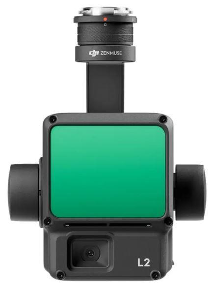
The frame-based design results in an effective point cloud data rate of up to 100%. Together with a three-axis gimbal, it brings more possibilities to surveying scenarios.
The high-accuracy self-developed IMU system, combined with the drone’s RTK positioning system for data fusion during post-processing, gives L2 access to highly accurate absolute position, speed, and attitude information. In addition, the IMU system’s enhanced environmental adaptability improves the operational reliability and precision of L2. Yaw Accuracy: Real-time: 0.2°, post-processing: 0.05°. Pitch/Roll Accuracy: Real-time 0.05°, post-processing 0.025°.
The performance of the IMU system has been significantly enhanced, and it is ready for use the moment it's powered on. And, the accompanying drone is ready to begin tasks immediately once the RTK is in FIX status, delivering an optimized in-the-field experience.
Pixel size has been enlarged to 3.3 μm, and effective pixels now reach 20 MP, resulting in a significant improvement in overall imaging, as well as more enriched true-color point cloud details. The minimum photo interval has been reduced to 0.7 seconds. The mapping camera has a shutter count of up to 200,000 times, further reducing operational costs. When point cloud collection is not needed, the RGB camera can still take photos and videos, or collect images for visible light mapping.

Zenmuse L2's intelligent recognition algorithm supports identification, tracking, and junction analysis for transmission and distribution lines, enabling semi-automatic flight and data collection. Supports Waypoint, Area, and Linear Route types, for handling surveying tasks in a variety of environments. During operation, DJI Pilot 2 supports three display modes - RGB, point cloud, and point cloud/RGB side-by-side display, presenting operational results in an intuitive way. Activating RNG (Laser Rangefinder) enables access to the distance information between the LiDAR module and the object in the center of the FOV, enhancing flight safety. It also supports four real-time point cloud coloring modes - Reflectivity, Height, Distance, and RGB. After the operation, the 3D point cloud model can be viewed directly in the album. 3D Point cloud models of multiple flights can also be merged, enabling on-site decision-making regarding operational quality. After point cloud data collection, the DJI Pilot 2 app will automatically generate a Task Quality Report so that operators can check operational results in real-time and on-site, making fieldwork more responsive and worry-free. In complex operational environments, users can set up RTK base stations before the operation to preemptively avoid the loss of RTK data due to interference, video transmission disconnection, or other issues. After the operation, import original files into DJI Terra to use the PPK (post-processing kinematic) process to rebuild high-precision models.
In coordination with DJI Enterprise flight platforms and DJI Terra, Zenmuse L2 can be applied to land surveying and mapping, electricity, forestry, and infrastructure management, as well as other scenarios. Land Surveying: Drone solutions collect accurate, geo-tagged data quickly, while photogrammetry software processes these data to deliver standardized outputs. Urban planning: Design and plan more effectively with 3D reality models that accurately reflect landform and architectural information. Obtain accurate 2D maps and 3D models of the landscape as frequently as required to ensure proper, up-to-date classification. Quickly map corridors such as rivers, bridges, and roads, creating accurate 2D and 3D models to facilitate maintenance and inspection. Architecture Engineering: Map large work sites to acquire detailed, precise data using drones. 2D maps and 3D models help teams optimize project planning and designs. Progress Monitoring: Drone solutions, along with image stitching and 3D modeling software help teams stay fully informed on site progress and resource allocation – keeping projects on time and on track. Building Inspection and Maintenance: Quickly map and model buildings to digitize the inspection and maintenance process, reducing costs while keeping personnel safe. Stockpile Volumetrics: Obtain accurate volume measurements of stockpiles and construction aggregates using 3D models built with aerial images. Heritage Site Modeling: Build detailed 3D models of cultural and natural heritage sites, digitizing assets for preservation and education. Forest Management: Deploy drones with high-resolution visual sensors and multispectral sensors to map forests, sample vegetation, or monitor and manage the health of forests and wildlife. Water Resource Management: Map around surface water, outfalls and more with drones to obtain data on-demand, facilitating resource management and compliance monitoring across vast areas.

Product Name: DJI Zenmuse L2
Dimensions (length x width x height): 155 × 128 × 176 mm
Weight: 905 ±5 g
Power: 28 W (typical), 58 W (max.)
IP Rating: IP54
Supported Aircraft: Matrice 300 RTK (requires DJI RC Plus), Matrice 350 RTK
Storage Temperature: -20° to 60° C
General Operating Temperature: -20° to 50° C
Detection Range: 450m @50% reflectivity, 0 klx; 250m @10% reflectivity, 100 klx. Typical data. Measured using a flat subject with a size larger than the laser beam diameter, perpendicular angle of incidence, and an atmospheric visibility of 23 km. In low-light environments, the laser beams can achieve the optimal detection range. If a laser beam hits more than one subject, the total laser transmitter power is split, and the achievable range is reduced. The maximum detection range is 500 m.
Point Cloud Rate: Single return: max. 240,000 pts/s; Multiple returns: max. 1,200,000 pts/s
System Accuracy: Horizontal: 5 cm @ 150 m; Vertical: 4 cm @ 150 m
Real-Time Point Cloud Coloring Coding: Reflectivity, Height, Distance, RGB
LiDAR Ranging Accuracy (RMS 1σ): 2 cm @ 150 m
Maximum Returns Supported: 5
Scanning Modes: Non-repetitive scanning pattern, Repetitive scanning pattern
FOV: Repetitive scanning pattern: Horizontal 70°, Vertical 3°; Non-repetitive scanning pattern: Horizontal 70°, Vertical 75°
Minimum Detection Range: 3 m
IMU Update Frequency: 200 Hz
Sensor of RGB Mapping Camera: 4/3 CMOS, Effective Pixels: 20 MP
Lens: FOV: 84°, Format Equivalent: 24 mm, Aperture: f/2.8-f/11, Focus Points: 1 m to ∞ (with autofocus)
Shutter Speed of RGB Mapping Camera: Mechanical Shutter: 2-1/2000 s, Electronic Shutter: 2-1/8000 s
Gimbal Stabilization System: 3-axis (tilt, roll, pan)
Raw Data Storage: Photo/IMU/Point cloud/GNSS/Calibration files
Point Cloud Data Storage: Real-time modeling data storage
Supported microSD Cards: microSD: Sequential writing speed 50 MB/s or above and UHS-I Speed Grade 3 rating or above; Max capacity: 256 GB. Use the recommended microSD cards.
Recommended microSD Cards: Lexar 1066x 64GB U3 A2 V30 microSDXC, Lexar 1066x 128GB U3 A2 V30 microSDXC, Kingston Canvas Go! Plus 128GB U3 A2 V30 microSDXC, Lexar 1066x 256GB U3 A2 V30 microSDXC
Warranty 24 months
Weight 0.905 kg
Delivery time 5-19 w.d.

| Producer(?) | DJI |
|---|---|
| Warranty | 24 months |
| Weight | 0.905 kg |
| Delivery time | 5-19 w.d. |
| Product codes |
06878EPB CP.EN.00000505.02 6941565971777 |
Email: [email protected]





Reviews
0 average rating (0 votes)